My focus is in Urban Geographic Information Systems with a certificate obtained from the Levin College of Urban Affairs while pursuing my Master’s in Urban Planning. Analyzing patterns and presenting abstract data visually, is my specialty.
Cleveland Lakefront & Riverfront Projects Map
Open in New Tab for Fullscreen ViewingDuring my time at the Greater Cleveland Partnership from February to September 2023, I developed the Waterfront Project Mapping Tool for the City of Cleveland. This project involved researching over 60 infrastructure projects and managing an up-to-date Excel databank. I crafted two user-friendly interactive web maps using Esri Experience Builder: one for experienced users with advanced features, and another simpler version for inexperienced users. These tools significantly enhanced project visualization and management in the Waterfront area.
GIS Research Project: Which Factors Correlate with Sars-Cov-2 Deaths?
Findings
Some of the most correlated risk factors for county-wide covid-19 death rates are physical inactivity, low education levels, living below the poverty line, smoking, and not having medical insurance. These factors vary from urban to non-urban to rural counties. Data were most representative for urban counties likely due to more data collection and availability.
GIS Research Project: Ethnic Community Engagement Handbook
Findings
In this research project, I worked as the team leader with two other members (Savannah Potter and Gabriella Eisel) who worked on providing data on community issues, and cultural and ethnic institutions. I analyzed which census tracts could be considered ethnic based on various factors from literature reviews. Finally, I developed the map below by summarizing our project’s research efforts into one cohesive product.
Limited conclusions we could draw were that dense clusters of cultural and ethnic institutions such as restaurants, religious institutions, and community centers seem to be related to lower community issues.
Urban Land Use Project: Youngstown Corridor and Site Analysis
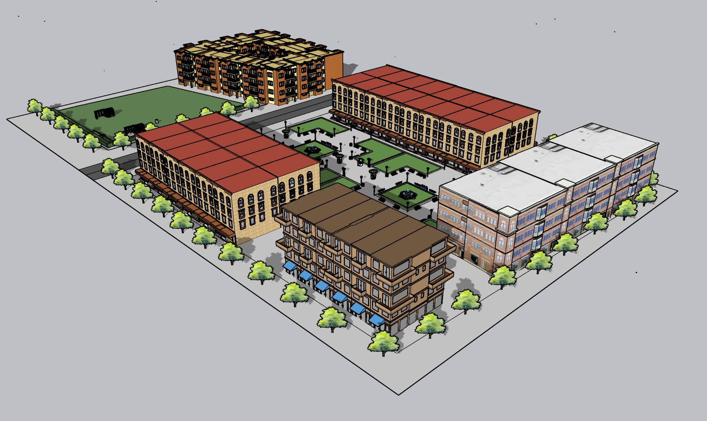
My part in a larger team project was to develop two specific site models to give different options for a potential catalyst site including housing, offices, businesses, retail, and green space.
Creating a 3D model for the whole corridor with google earth integration served to showcase the massing and fit of new proposed land uses.
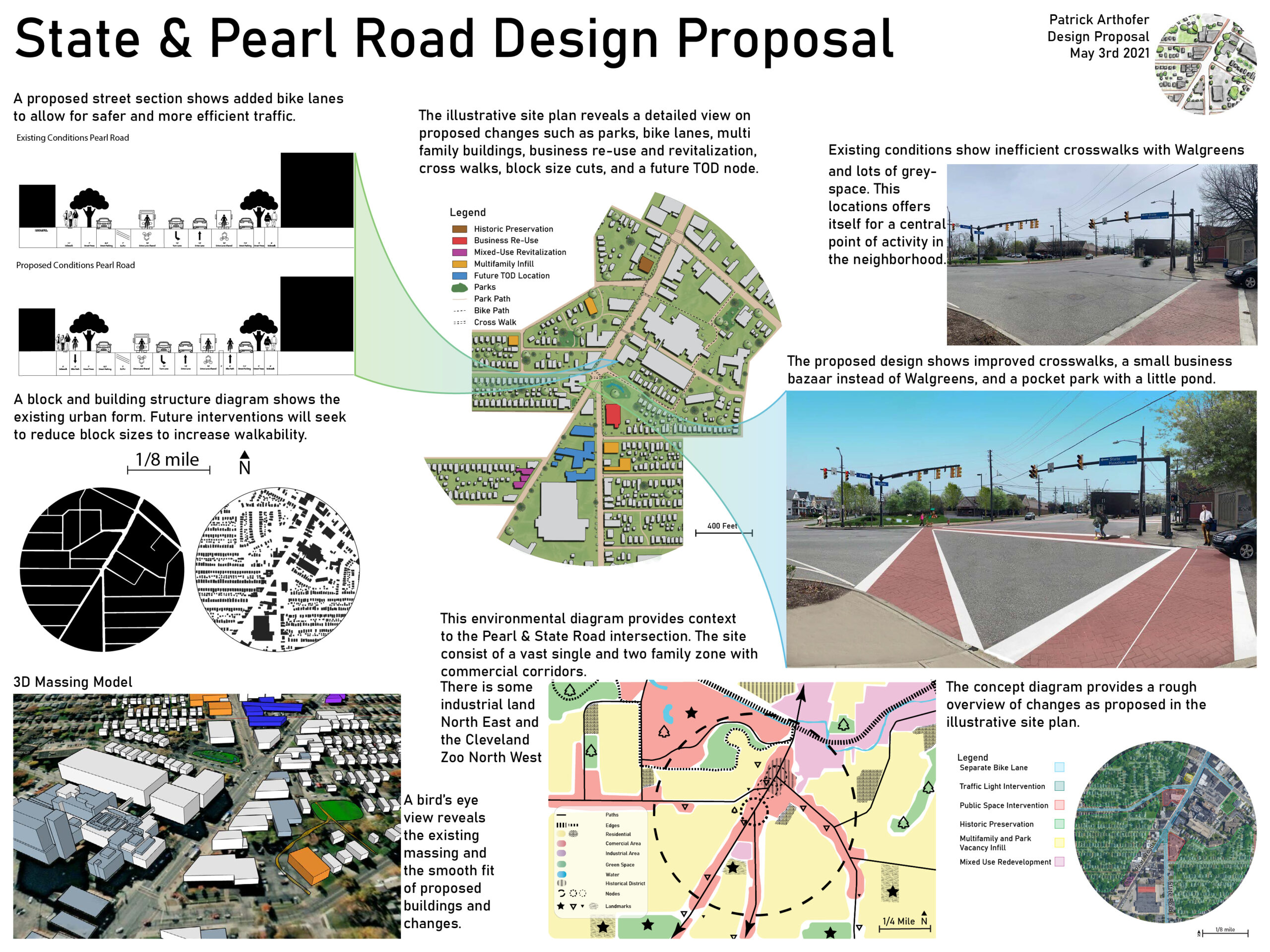
Urban Design Project: State & Pearl Road Site Analysis
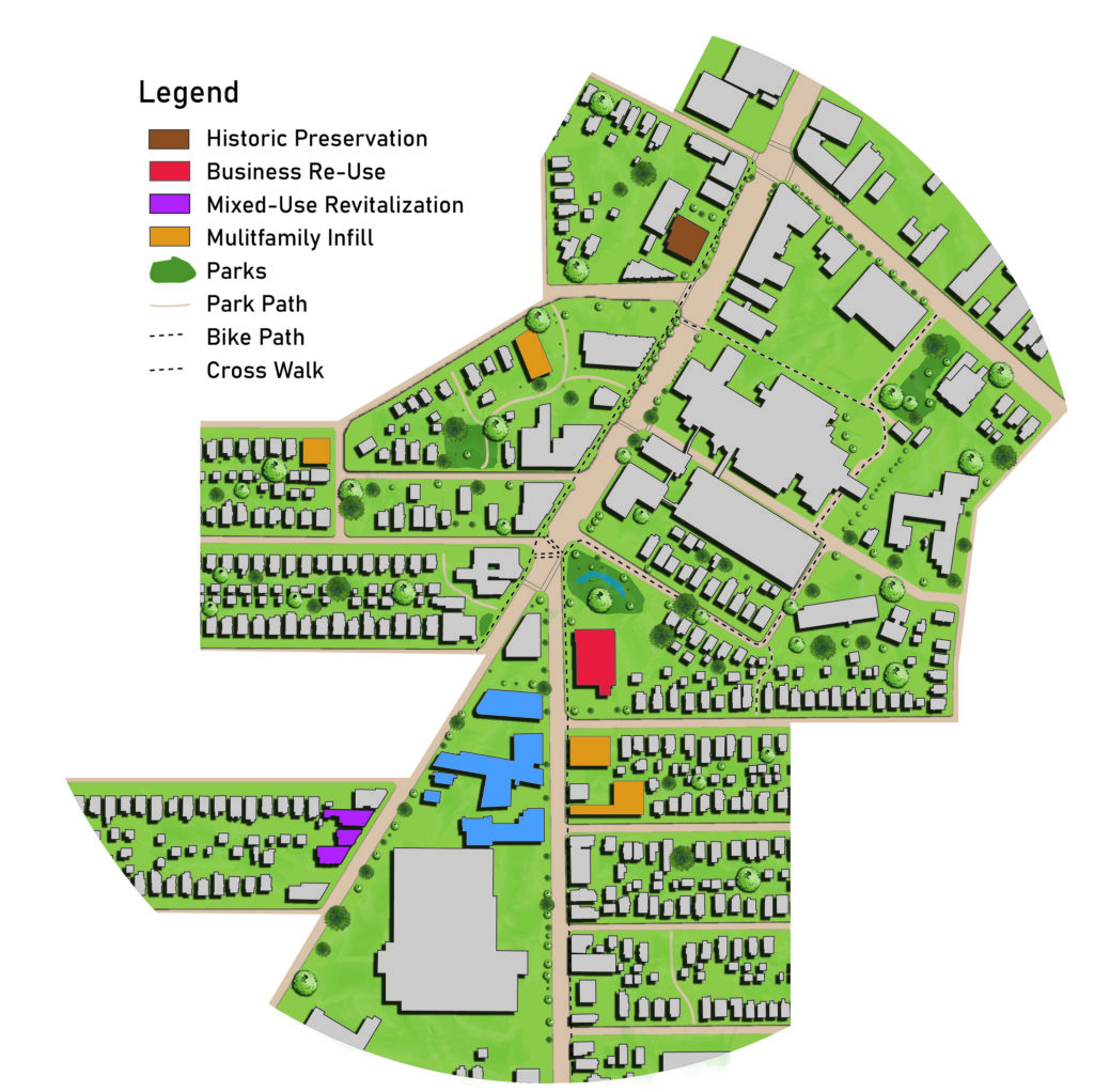

This project specifically concerns itself with improving the intersection of State & Pearl Road in Cleveland, Ohio. The analysis takes into account a variety of urban planning techniques such as street cross-section, photo morphs, 3D massing models, site plans, and historic blocks and building diagrams.
Design recommendations included connecting greenspace by walk and bike paths, reducing block sizes for more walkability, and replacing a drug store with community space for things like farmer markets to create a focal point around the pedestrian activity which was detected in a behavioral observation study.
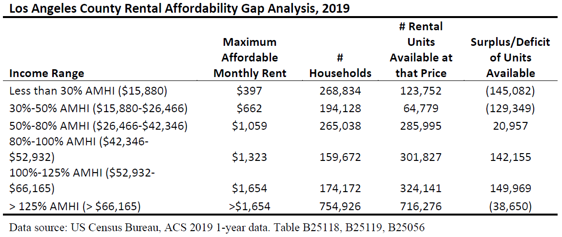
Regional Analysis Project: Conditions Report L.A. County, California 2010-2019
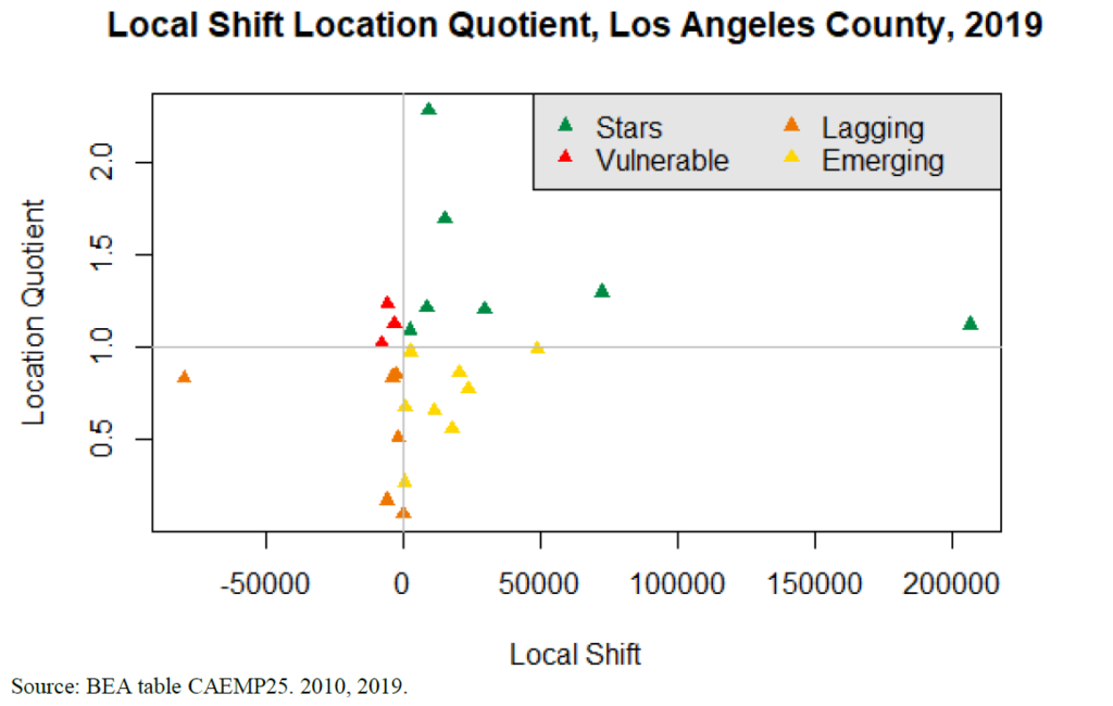
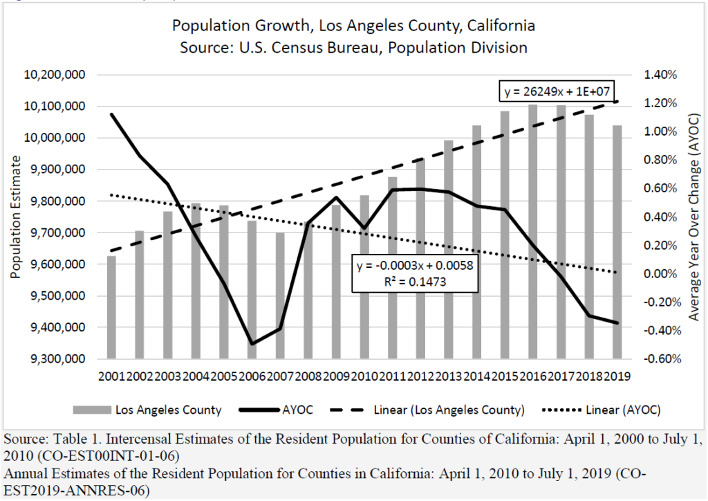
This regional analysis focuses on Los Angeles County and compares the current conditions (2019) to 2010. The analysis includes demographics, population trends and pyramids, housing and rent analysis and projections, rent gap analysis, economic analysis, transportation, and workforce analysis.
The report shows that urban sprawl is an issue related to long commute times. Furthermore, real estate market speculation and holding rental and real property off the market create barriers to more efficient housing within city limits, feeding into the urban sprawl issue.
Urban Planning Capstone Project: Lorain Downtown Broadway
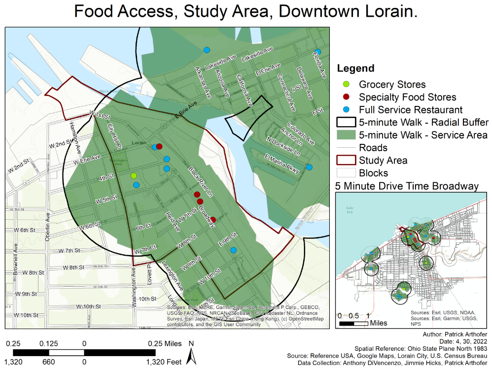
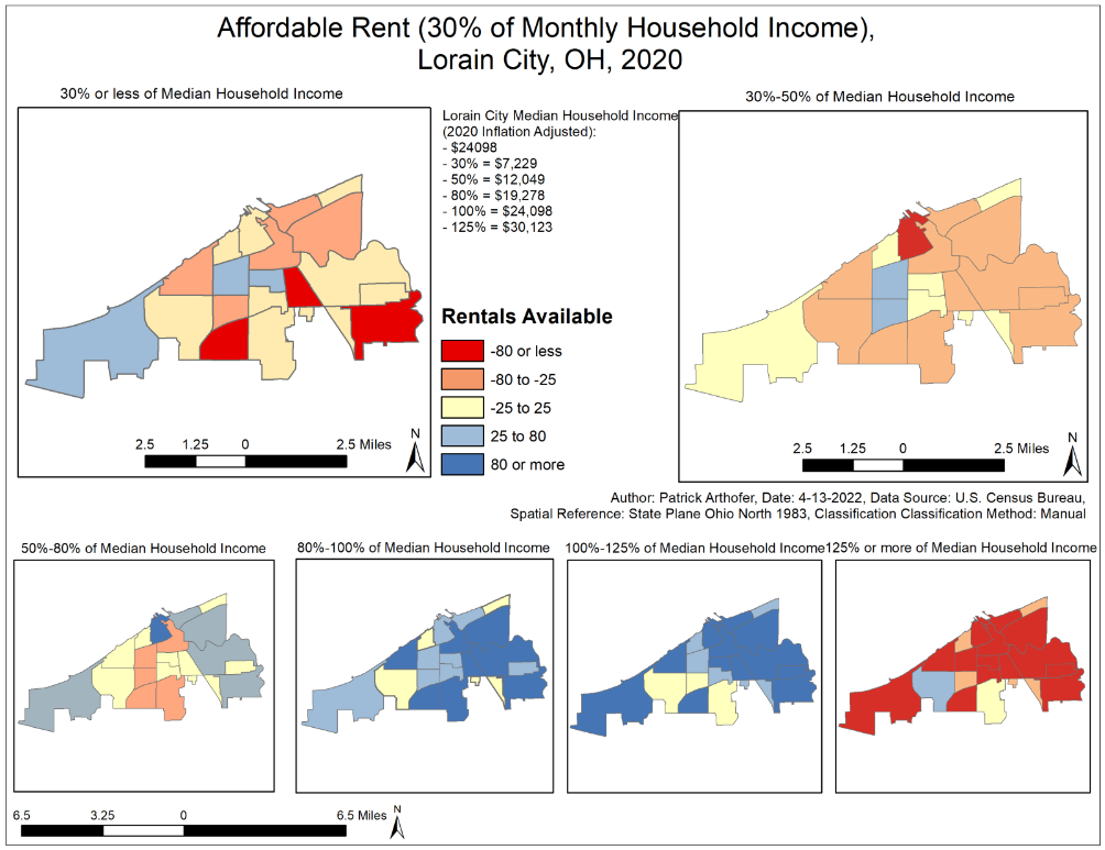
For our capstone Urban Planning project, I mainly provided GIS support, worked on a market study, and created this story map below, summarizing our project about revitalizing Downtown Lorain, OH. Furthermore, I created a rent gap analysis for the census tracts in Lorain City, OH, and presented it visually as a map instead of a table.